The “numerous” crises linked to the environmental disaster of Lake Chad

Filippo Verre - March 27, 2022
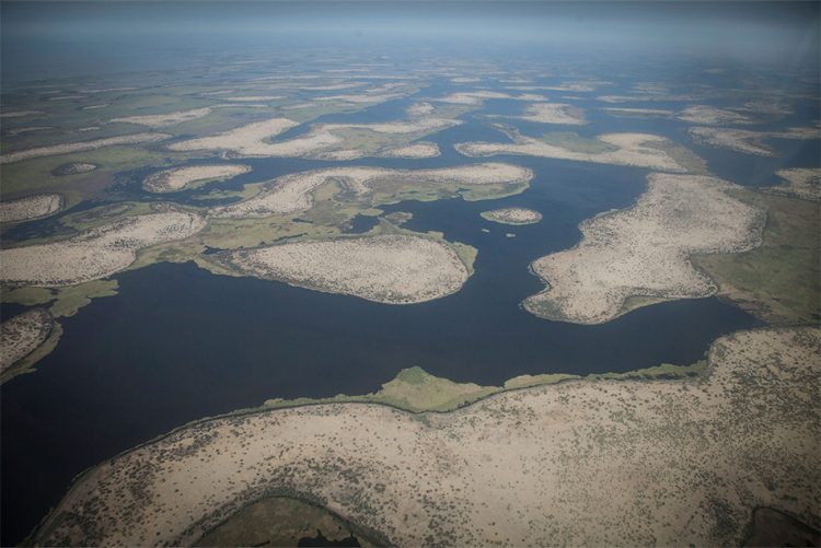
* L’immagine di copertina di questo paper è stata presa dal sito Go World, alla sezione Go Afrique consultabile al seguente link: https://www.goafrique.it/cenni-sul-lago-ciad-lago-africano-oggi-ridotto-nella-sua-estensione/
Environmental crises are one of the main reasons why human beings decide to emigrate. Wars, famines, lack of economic prospects and development are not the only, albeit very valid, reasons that push millions of individuals to leave everything behind to seek a better future. In this peculiar historical moment, environmental crises, especially if linked to difficulties in water supply, represent a factor that must necessarily be taken into consideration to correctly study migratory dynamics. The difficult and, in some ways, very worrying situation of Lake Chad fits perfectly into this perspective. Currently, this large water basin is going through a very serious crisis that significantly impacts the life, society and economy of approximately 30/35 million people living near the lake. This issue, moreover, concerns us very closely, given that a high number of migrants from Africa headed to Italy come from northern Nigeria, an area directly affected by the environmental crisis underway in Lake Chad.
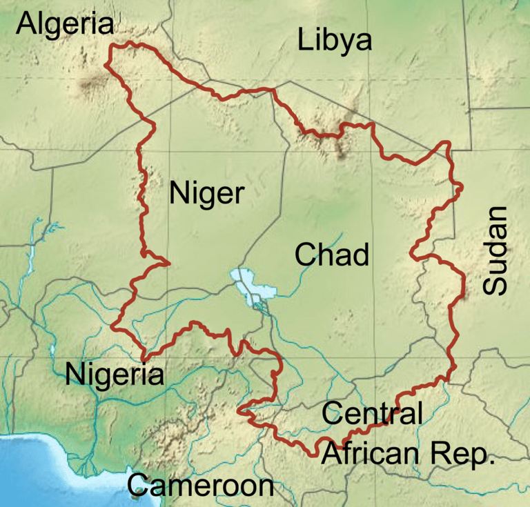

Fig. 1: Geo-localizzazione del Lago Ciad
For a series of factors, which will be discussed in this paper, the crisis that characterizes Lake Chad reaches a decidedly worrying level of criticality. As is known, many ecosystems today are subject to worrying alterations. These are mostly caused by environmental factors, including climate change, or by human interventions. As often happens, an environmental crisis is associated with a socioeconomic one, since even today human communities draw much of their sustenance from the territory in which they reside. However, what is happening in the Lake Chad basin goes beyond the "simple" environmental crisis with the usual negative effects on the social and economic level. In fact, the difficult situation in terms of water supply, desertification and lack of economic development is added to a series of political-administrative issues that make the basin of this lake one of the most inhospitable areas in the world.
“Environmental” History of Lake Chad
At the time of writing, Chad is a medium-large transboundary lake that occupies a surface area belonging to four African states located in the south-western Sahel. As can be seen from Fig. 1, the states are Niger, Chad, Cameroon and Nigeria. The extension of the water basin in question is just over 1,500 km², in constant decline for about sixty years. Only a few decades ago, in fact, Chad had an extension of absolute respect and represented a very important water reserve for central-western Africa. This situation is well photographed by the numbers. In the last sixty years the surface of the lake has reduced by over 90%, going, in the rainy season, from 25,000 km² in 1960 to the current 1,540. For a graphical confirmation of this situation, please consult Figs. 2 and 3.
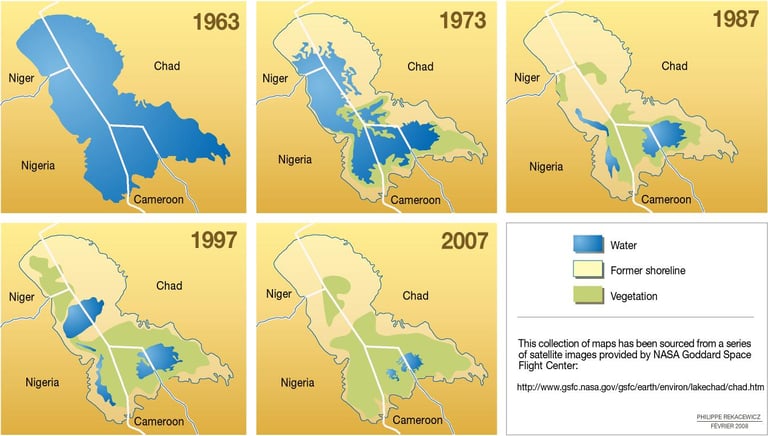

Fig. 2: Progressiva erosione della superficie idrica del Lago Ciad dal 1963 al 2007
There are many reasons why this important lake has seen its flow progressively reduced. First of all, the geological conformation of the water basin being analyzed must be taken into consideration. Lake Chad is technically “endorheic”, that is, it is a hydrographic basin without outlets. Usually, endorheic depressions are found within vast continental areas, tectonically stable, where large local topographic depressions constitute a point of convergence for the circulation of surface waters, which form the lakes. The latter can also be of very large proportions, even forming the so-called “internal seas”. An example of this type is the Caspian Sea, the largest lake in the world (371,000 km²), located at the center of an endorheic basin extending over several million km² which includes, among others, the catchment basins of the Volga and Ural rivers. Endorheic regions can develop in any climate, but are mainly found in desert areas, as in the case of Lake Chad, which is located in the southern reaches of the Sahara, the largest desert in the world.
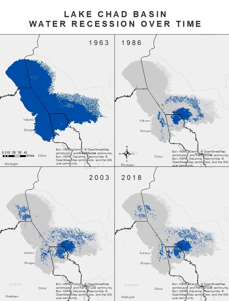

Fig. 3: Costante diminuzione della superficie idrica del Lago Ciad dal 1963 al 2018
With no outlets, Chad receives only the waters of the Logone and the Chari, which flow into it to form a vast delta southwest of the Komadugu-Yobe[1], a medium-large river in West Africa that marks the border between Nigeria and Niger. The lack of outlets means that Chad is a lake where the water supply is often subject to the volume of rainfall. One of the characteristics of the lake, in fact, is its shallowness, a sign of a poor water supply that has prevented the formation of a deep basin. On average, Chad has a depth of 1.5 meters, with peaks reaching 11 meters. This is very little, especially if the watercourse in question is subject to recurring water crises. This situation means that, in the event of drought, there is not a “simple” lowering of the waters but, far more problematic, a real drying of entire areas can occur, depending on the intensity of the crisis at the time.
According to some theories, present-day Chad would be the remnant of a large internal sea that in the Pleistocene[2] had an enormous extension, of about 400,000 km². The latter, renamed by experts Mega Chad, would have progressively dried up until reaching the worrying dimensions of today. As can be seen from Fig. 4, Lake Chad of today is nothing more than a "pond" if compared to the large internal sea of the past. Equipped with significant depressions, which reached even 180 meters in depth, Mega Chad constituted the main water reserve of central-western Africa.
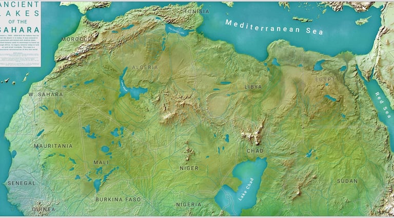

Fig. 4: Estensione del Mega Chad secondo alcune proiezioni idrografiche
As mentioned, given the substantial absence of emissaries, Chad necessarily relies on rainfall for approximately 90% of its water supply. In the event of a reduction in the volume of rainfall, the main supply line fails, effectively putting the lake's water resources into difficulty. In this regard, one of the causes of the slow and unstoppable drying process that has characterized Chad in recent decades is the strong reduction in the volume of rainfall that has recently characterized West Africa. The terrible droughts that have hit the Sahel region in the last thirty years, the result of low rainfall, have certainly favored the progressive erosion of the lake's water resources. According to the data, there has been a confirmed rainfall deficit of 50-65% since 1970[3]. This has contributed to making a situation that was already slowly worsening critical, especially given the shallow average depth that characterizes, as already analyzed, Lake Chad. The thirty-year drought has also favored a massive evaporation of water, thus further stressing the already struggling water basin.
The Sahel region in which Chad is located is currently one of the areas most subject to climate change in the entire African continent. In fact, long periods of severe drought have alternated with short but very intense torrential rainfall events that have, if possible, even worsened the situation. In this regard, it should be noted that in 2020 the affected area recorded the heaviest rainfall in recent decades. This has disrupted the lives of hundreds of thousands of families, destroying or causing serious damage to villages and fields and forcing over a million people to move. As a result, hunger and malnutrition remain at critical levels, despite the presence of rainfall that, at least in theory, could have brought some benefit to the populations living near the lake. Instead, according to the latest data released by the United Nations, about ten million people in the area live in a serious situation of food insecurity, due mostly to the difficulty of water supply[4].
The numerous crises that characterize the Chad water basin
The difficult environmental situation that characterizes Lake Chad has given rise to a worrying series of events that have visibly worsened the living conditions of those who live near the water basin. First of all, the lowering of the waters has caused a notable worsening in terms of economic and production. The progressive drying up of the lake has literally brought the once flourishing fishing sector to its knees. In this perspective, consider that the production of dried fish has gone from 140,000 tons in 1960 to 45,000 today[5]. This has generated, over time, the forced migration of millions of Africans who, before the current environmental crisis, relied on the rich waters of Chad.
In addition, it is important to keep in mind the serious damage that the lack of water has caused to socio-economic exchanges. In the past, the lake was often used as a real "waterway" through which numerous commercial exchanges were organised daily at all latitudes of the large water basin. The main people responsible for this intense economic activity were the so-called pirogueri, a group of navigation workers who were responsible for transporting goods and people from one shore of Chad to the other. As reported in various studies carried out in recent times[6], the pirogueri have been the driving force of local trade for decades, being the backbone of a flourishing economy based on social and commercial exchanges that has made the Lake Chad basin an important sub-regional centre. In fact, as correctly underlined by Luigi Limone, compared to road transport, boats offered a faster solution to deliver large quantities of goods. This meant income for transporters and traders on the one hand and lower prices for consumers on the other[7].
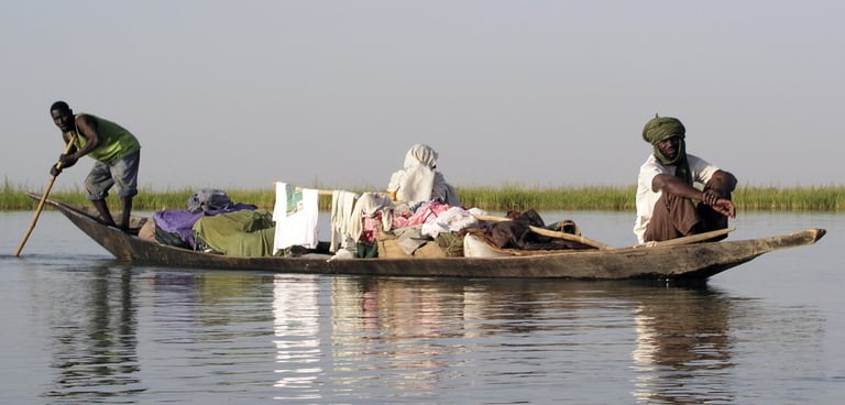

Fig. 5: Piroghiere in azione
In addition to the economic and productive problems, which have certainly dealt a serious blow to the already fragile standard of living of the millions of Africans living near the lake, there are serious issues regarding "agricultural conflicts". As one can imagine, in addition to being a means of transport necessary for trade, the lake served above all as a water basin from which to draw for many farming families. In fact, one of the reasons that accelerated the current crisis of Lake Chad is precisely linked to the indiscriminate and uncontrolled use of water resources for agricultural and pastoral purposes. Over time, countless African farmers and ranchers have made massive use of the lake's waters. However, if in the past this was "only" an environmental problem, given the constant erosion of water resources that these uncontrolled practices caused, today the situation is very different. As can be clearly seen in Figs. 2 and 3, the lake is now only of some importance in Chad and Cameroon, since in Nigeria it is almost completely dried up and in Niger there are only muddy swamps left. This often causes Nigerian and Nigerien farmers to enter Chadian and Cameroonian territory to access the lake's waters, inevitably generating tensions both at a local level and in the context of bilateral relations between the states involved. These practices are now so frequent that it is not wrong to define such clashes between farmers, with the related diplomatic repercussions, as real "trans-border agricultural conflicts".
In addition, the strong socio-political degradation in which the Chad basin finds itself following its progressive drying up must not be forgotten. The serious worsening of the economic conditions of millions of families has inevitably favored the emergence of phenomena linked to crime. Particularly frequent are episodes of cattle theft, raids and damage, often favored by the food insecurity that now characterizes the entire Lake Chad basin. As if that were not enough, this situation, already critical in itself, is further exacerbated by the presence in the territory of various jihadist groups, above all the Islamic State's West Africa Province (ISWAP), the African branch of ISIS. Better known as Boko Haram, the organization intends to exploit the ongoing crisis to expand its influence in an attempt to create a real Islamic State in the Lake Chad region. The terrorist organization seeks to insert itself into the struggling ganglia of the lake communities, taking advantage of the difficulties encountered by national government authorities in managing the water crisis. In addition to the increase in crime, the loss of the wealth that the lake once represented has encouraged terrorist groups to recruit fishermen from small villages and has encouraged a massive migration to urban centers, sending cities in the area into a terrible state of distress that were already suffering and are still suffering from recurring crises related to water supply.
Future prospects
As we have seen, the situation of Lake Chad is certainly not rosy. Without too many turns of phrase, we are on the brink of a real environmental catastrophe that could, and in part has already caused, to generate a migration crisis with very dark consequences. To avoid an end that seems to be inevitable, the nations involved have created a supranational organization responsible for the management of the lake: the Lake Chad Basin Commission (LCBC). To be fair, this commission is extremely dated, given that it was established way back in 1964 by the four states bordering Chad. The LCBC currently comprises eight members, the four founders plus Algeria, the Central African Republic, Libya and Sudan (the latter were chosen because of their proximity to Lake Chad). There is also an annual budget of one million dollars for the management of the Commission, to be distributed as follows: Nigeria 52%, Cameroon 26%, Chad 11%, Niger 7%, Central African Republic 4%.
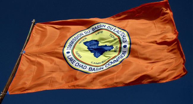

Fig. 6: Logo della Lake Chad Basin Commission (LCBC)
Nonostante la presenza di un’organizzazione sovranazionale preposta alla salvaguardia del Ciad, la situazione non ha fatto che deteriorarsi negli ultimi cinquant’anni, fino ad arrivare quasi al capolinea odierno. Ciò è dovuto in massima parte alla difficoltà nell’elaborazione di una strategia congiunta volta alla preservazione delle risorse idriche e al contrasto delle pratiche scorrette. Essendo stata fondata nel 1964, ovvero quando il bacino idrico non riscontrava particolari problematiche, la LCBC aveva tutti i presupposti per portare a compimento un risultato più soddisfacente di quello attuale. Non si dimentichi, infatti, che la Commissione è la più “longeva” organizzazione africana di Stati che condividono sul proprio territorio un fiume o un lago. Dunque, le condizioni per realizzare un lavoro di qualità non mancavano di certo. La non perfetta gestione delle risorse idriche da parte dei governi locali, che hanno sistematicamente ignorato gli allarmi degli scienziati e continuato a sfruttare indiscriminatamente le acque con canali di drenaggio per l’irrigazione delle aree coltivabili, ha di fatto annullato qualunque tentativo di trovare una soluzione congiunta ad un problema che resta, senza dubbio, comune.
Nel momento in cui si scrive, ovvero in una situazione di estrema emergenza, si segnala la presenza di una serie di proposte finalizzate alla salvaguardia del Lago Ciad. Tra le misure prese in considerazione è opportuno menzionare la realizzazione di un canale di oltre 100 km (con un costo stimato in sette milioni di dollari) per immettere nel Ciad parte delle acque del Oubangui, un affluente del Congo che segna il confine meridionale della Repubblica Centrafricana. In tal modo, gli scienziati ritengono che il lago riceverebbe un importante apporto idrico in grado di garantirne la sopravvivenza. Al momento questa sembra essere la strada più facilmente percorribile, visto che è stato ufficialmente abbandonato un faraonico progetto che puntava ad innalzare il livello idrico del Ciad tramite il prosciugamento di un’importantissima zona umida del Sudan meridionale, ovvero un sistema paludoso di 8000 km².
___________________________________________________________________________________________________________________________________________________________________
[1] Il Komadugu-Yobe è un fiume trans-frontaliero di considerevoli dimensioni, caratterizzato da un bacino idrografico (148.000 km²) che svolge una funzione importante sia per la Nigeria che per il Niger. Lungo 1.200 km e con una portata media di 15 m³/s, questo corso d’acqua è situato nel nord della Nigeria (per circa 85.000 km²), nel sud-est del Niger (circa. 65.000 km²).
[2] Precisamente tra 41.000 e 2.300 anni fa. https://www.britannica.com/place/Chad-Basin#ref1068345.
[3] https://www.globalgeografia.com/africa/lago_ciad.htm.
[4] https://www.africarivista.it/la-scomparsa-del-lago-ciad-una-crisi-ambientale-e-umanitaria/180074.
[5] https://www.africarivista.it/la-scomparsa-del-lago-ciad-una-crisi-ambientale-e-umanitaria/180074/.
[6] https://www.bbc.com/news/world-africa-43500314.
[7] https://www.africarivista.it/la-scomparsa-del-lago-ciad-una-crisi-ambientale-e-umanitaria/180074/.
Abaqua
Via Cassia, 615
00189 Roma (RM)
© 2024. All rights reserved.
Codice Fiscale: 96584590580
