The Great Hydro-Strategic Value of Tibet
Filippo Verre - January 23, 2022

* L’immagine di copertina di questo report è stata presa dal sito Times of India, consultabile al seguente link: https://timesofindia.indiatimes.com/blogs/echoes-from-the-himalayas/70-years-of-colonization-of-tibet-by-china-tibetans-are-a-minority-on-their-own-land/
With a surface area of approximately 1,200,000 square kilometers, Tibet is the largest plateau in the world. In this massive region, located largely on Chinese national territory, reside the highest mountains on earth; by virtue of this, Tibet is also internationally known as the "roof of the world". The presence of imposing mountain ranges means that in Tibet there are glaciers of large proportions, which feed some of the most important waterways on the Asian continent. To get an idea of the role that this large plateau plays at a hydro-strategic level, keep in mind that rivers of absolute pre-eminence such as the Ganges, Indus and Mekong flow right from the Tibetan mountains. This contributes to making this wild and inhospitable land one of the most strategic regions on the planet, especially by virtue of the constant growth in demand for water both at an energy level and with regards to the primary needs of human life. The large water resources present in Tibet, if properly exploited, can allow the production of high levels of hydroelectric energy at relatively low costs and with low environmental impacts. Furthermore, the impetuous increase in the world population, which has had one of the most visible demographic impacts in Asia, has made even more evident the great importance that Tibet holds as an Asian water "reservoir".
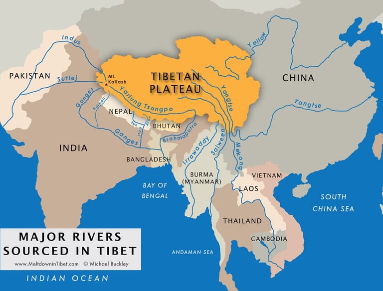

Fig. 1: I principali fiumi asiatici che scorgano dall’altopiano tibetano
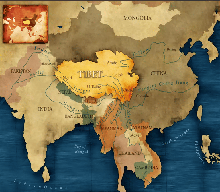
China was among the first Asian nations to realize the great importance of Tibet at a hydro-strategic level. In 1950, Mao Zedong, leader of the People's Republic established in October 1949, annexed the western and southern reaches of Tibet to ensure that the newly formed communist republic had the water resources necessary to support hundreds of millions of people. Mainland China is a gigantic mass of mostly arid land, where the presence of water is not so massive. If we exclude the drainage basins of the Yellow River and the Yangtse, two large waterways considered to be at the origins of Chinese civilization, the water resources on which Beijing can rely are not many. Hence, the political-strategic choice to exercise tight control over the Tibetan plateau which, as can be seen in Figure 1, is the region from which the "water veins" of Southeast Asia flow.
Tibetan Water Importance on the Indo-Bangladeshi Side
As one can imagine, Beijing's strong grip on Tibet gives China a great geopolitical advantage on a continental level. In the current era, characterized by various factors including mass urbanization, climate change and indiscriminate increase in the world population, those who hold a firm control over the sources of water supply acquire a position of absolute pre-eminence. Simply put, if Beijing were to decide from one day to the next to "turn off the taps", approximately 500 million people, mostly Indians and Bangladeshis, would not have the necessary water resources to carry on a normal life. In this regard, among the Tibetan waterways that are most relevant in a trans-border geopolitical key is undoubtedly the Brahmaputra. This great river is the main source of water supply for Bangladesh, a densely populated Asian nation [1] where frequent cases of uncontrolled mass urbanization occur. In this regard, take the case of Dhaka, the capital of Bangladesh with more than 15 million inhabitants and which holds the tenth place in the world ranking of the most populous urban centers. In the last 20 years the city has experienced a real demographic boom; this was followed by the usual problems of water supply connected to rapid population growth: water scarcity, pollution of aquifers, suspension of water services.
The Brahmaputra plays a role of absolute importance for the economy and society of Bangladesh. In fact, it, together with the Ganges, another large river that meets the aforementioned in Bangladesh before flowing into the Bay of Bengal, forms one of the most important hydrographic basins of the Asian continent (670,000 km²). The Brahmaputra is a considerable river both in length (2,900 km total) and in flow (30,000 m³/s). However, as can be seen from Fig. 2, this mighty watercourse only crosses Bangladesh for a short distance.
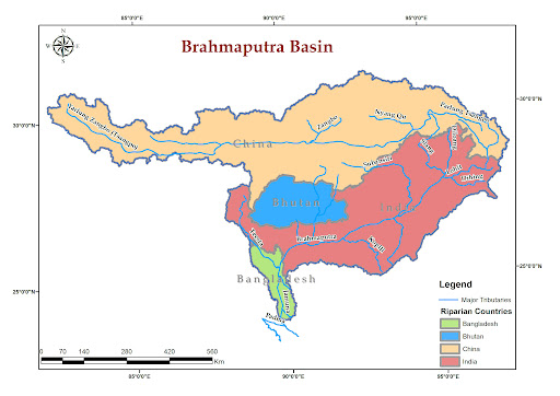

Fig. 2: Bacino idrografico del fiume Brahmaputra
In fact, this watercourse represents the trans-border river par excellence, since it crosses not one, but two states (China and India) before entering Bangladesh. This constitutes a serious problem for the Bangladeshi people, given that there are critical issues both in terms of quantity and quality of the water that reaches “downstream”. Various dams are present on the course of the Yarlung Tsangpo, the name by which the Chinese call the Brahmaputra that flows on the Tibetan side. Furthermore, India has also built a series of water infrastructures on the banks of the Jamuna, the name by which the citizens of Arunachal Pradesh, a north-eastern Indian state, usually refer to the Brahmaputra. This results in a limited water flow on Bangladeshi territory, given that the various Chinese and Indian dams “upstream” significantly affect the volume of water that actually flows towards the Bay of Bengal.
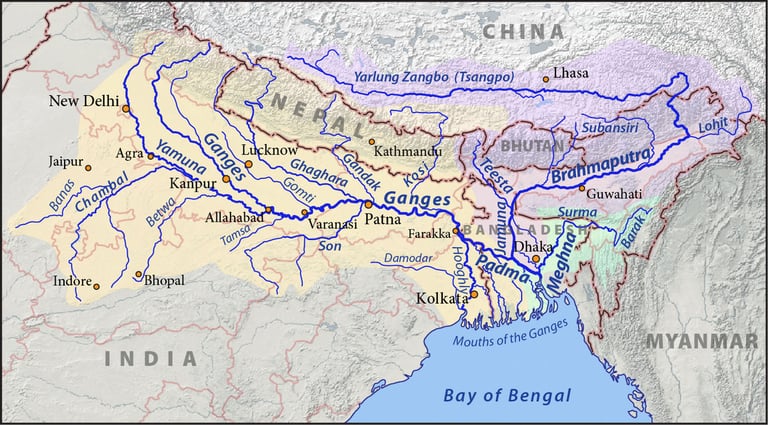

Fig. 3: Bacino idrico del Brahmaputra e del Gange
Furthermore, even from a qualitative point of view the situation is not the best. Precisely because of the numerous existing hydraulic structures and the intensity with which China and India exploit its waters for energy purposes, the Brahmaputra is a very polluted river. Among the most polluting materials there is a strong presence of arsenic; according to data from the World Health Organization, approximately 77 million Bangladeshi citizens are exposed to "significant risks to their health due to high levels of arsenic present in the water, in the territory and in the subsoil" [2]. To fully understand the implications of this serious situation, keep in mind that, according to the United Nations, the crisis of water contaminated by arsenic in Bangladesh is the most serious case of collective poisoning in the history of a human population [3].
In addition to the complex situation in Bangladesh regarding the management of the waters of the Brahmaputra, Tibet is also of great importance with regard to bilateral relations between China and India. These two Asian giants have often had diplomatic frictions precisely because of water issues. As highlighted in Fig. 1, the Tibetan plateau is crucial for the supply of northern India. The Ganges, which rises on the Indian side of Tibet, receives two important tributaries from the north: the Arun and the Koshi. These two rivers, whose drainage basins are respectively 33,600 km² and 29,400 km², contribute to supplying the Ganges with millions of cubic meters of water per day. Any alterations to their flow by China could inevitably generate limitations "downstream", thus causing serious inconvenience to millions of Indians. In addition, the issue of the Indus and the Sutlej, two other large rivers that rise on the Chinese side of Tibet and flow for a long stretch in northern India before entering Pakistan, should not be overlooked.
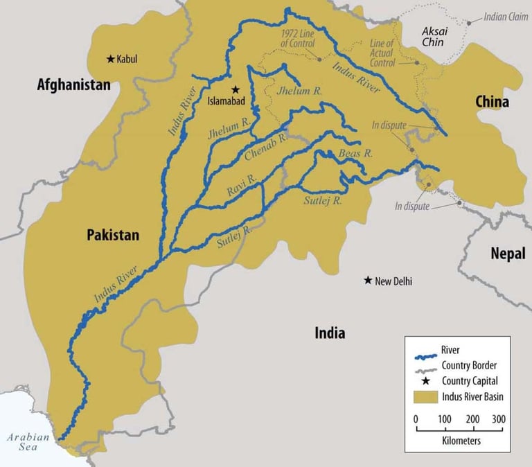

Fig. 4: Bacino idrografico dell’Indo e del Sutlej
As can be seen from Fig. 4, both the Sutlej and the Indus actually originate in Chinese territory, which gives Beijing a huge geopolitical advantage over New Delhi. The Sutlej, which has a rather large drainage basin (395,000 km²), plays a key role in the agricultural sector of northern India. Hundreds of canals have been built over time to divert the waters of this river to artificial reservoirs for irrigation. India uses the water resources of the Sutlej so massively that, according to Pakistani sources, the flow that reaches “downstream” in Pakistan is very small. This has created strong reasons for conflict between the two countries in the past, which, as is known, have often been in a state of serious tension.
The Indus is also extremely important for the economy and society of northern India. It should not be forgotten, in fact, that this river is historically considered, like others, to be the basis of Indian civilization. The name itself is a direct reference to India and its culture. In addition, consider the quantitative relevance that this great watercourse has. The Indus is the longest river in the Indian subcontinent (about 3,180 km) and the third largest in Asia in terms of annual flow. According to various experts, moreover, the Indus River has one of the largest hydrographic basins in the world: 1,165,000 km². As can be clearly seen in Fig. 4, this river also plays a role of absolute importance for Pakistan. In fact, the Indus represents a vital water resource for the entire economy of Pakistan, especially for the provinces of Punjab (the largest agricultural region of the country) and Sindh. In this regard, note that the word "Punjab" is a combination of the Persian words panj "five", and āb "water" which, with an extensive meaning, therefore corresponds to "Land of the Five Rivers". The five rivers that give Punjab its name are the Beas, Jhelum, Chenab, Ravi and Sutlej, all of which are tributaries or sub-tributaries of the Indus. The river is also essential for various heavy industries in Pakistan and is the country's main source of drinking water.
China's control over Tibet is of considerable concern to Indian diplomacy. Over the next 20 years, India will surpass China in population, becoming the world's most populous country. This means that New Delhi's demand for water resources will continue to increase for the foreseeable future. If we add to this the chaotic and often uncontrolled mass urbanization that characterizes Indian metropolises, it is very clear that access to water is a constant concern in India. In this context of latent tension, due to China's role as a hegemonic "water" power on the Himalayan front, the clash that took place in September 2020 between soldiers belonging to the two armies in question should not be surprising. Specifically, on September 7, 2020, several gunshots were fired during a conflict between Chinese and Indian soldiers along the disputed border between the two nations. The incident caused quite a stir, since despite the “cold” tensions between the two sides, the echo of bullets had not been heard in the area for over 45 years. This is because the use of firearms is prohibited by a joint agreement signed to avoid dangerous escalations. The episode in September 2020 followed the unfortunate and never fully clarified clash that occurred in June of the same year, when around twenty Indian soldiers and an unspecified number of Chinese soldiers lost their lives due to the most serious incident in recent decades between the two contenders.
Tibet's hydro-strategic importance in Indochina
From a water point of view, Tibet is extremely important also on the Indochinese side. As can be seen from Fig. 1, in fact, there are many watercourses of considerable size that flow from the Tibetan plateau and that head towards Indochina. Also in this case, thanks to its favorable geographical position "upstream", China is undoubtedly the nation with the most advantage from a strategic point of view. This advantageous situation is very evident in the case of Myanmar. In this important country overlooking the Bay of Bengal and with a fundamental "hinge" function between China and India, not one, but two large rivers are in fact easily controlled by Beijing. Both the Irrawaddy and the Salween, which are essentially the two watercourses on which Burmese society and culture have been based for centuries, originate in Chinese Tibet. Concretely, from a water supply point of view, Myanmar depends almost entirely on the flow of these two rivers. To get a precise idea of this dependence, please consider Fig. 5.
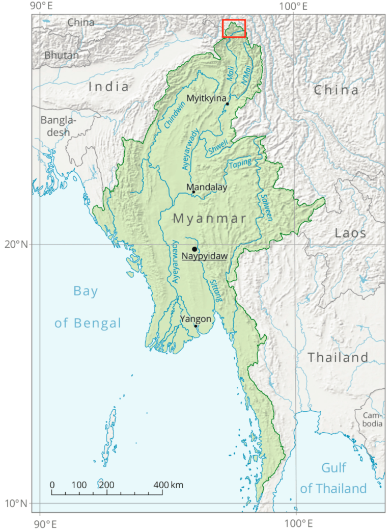

Fig. 5: Mappa geografica del Myanmar con relativi dettagli fluviali
The Irrawaddy and the Salween, with large water basins (411,000 km² and 320,000 km² respectively) and a significant length (2,170 km and 2,815 km respectively), constitute the Burmese water reservoir. The first, in particular, plays a major role at an industrial and agricultural level, especially by virtue of the large delta that distinguishes it. As can be seen in Fig. 5, the Irrawaddy delta is very large, reaching even to embrace Yangon (or Rangoon), the most populous city in the country which was, moreover, the capital until November 2005[4].
Beijing has exercised and still exercises solid control over both of these large rivers. It should be noted, however, that between the two, it is certainly the Irrawaddy that arouses greater interest. In this regard, not long ago the Chinese had shown great interest in building a massive hydraulic infrastructure (the Mytsone Dam) on the Irrawaddy. The dam, for the construction of which China was willing to spend about 20 billion dollars, would have constituted a fundamental energy resource for Yunnan, a Chinese region located on the border with Myanmar. In Beijing's plans, the hydroelectric energy produced by the Mytsone Dam would have been directed towards Kunming, the capital of Yunnan, in order to favor the industrial growth of a historically not very developed region.
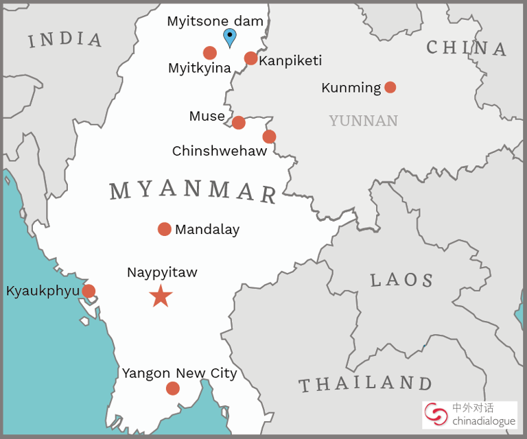

Fig. 6: La regione dello Yunnan al confine con Myanmar
The first works for the construction of the dam saw the light in 2007, when Myanmar was still governed by the military junta that had taken power following the 1990 coup d'état. However, in September 2011 Myanmar unilaterally decided to interrupt the construction of the large hydraulic infrastructure. The democratic turning point that characterized the country starting from 2011, which was also responsible for the fall of the military junta in power since the 1990s, had among other results that of partially excluding Beijing from Burmese internal affairs. The Mytsone dam, given the strong environmental and economic impact on various Burmese populations "downstream" in the face of direct benefits mainly towards a Chinese region, was considered an infrastructure not useful for the purposes of the development of Myanmar [5].
In addition to the two main Burmese rivers, it is appropriate to point out the great strategic function exercised by Chinese Tibet on another important Indochinese watercourse: the Mekong. The latter is probably the most important trans-border river on the Asian continent. As we have seen, from the Brahmaputra to the Indus, there are various trans-border rivers that originate in Chinese Tibet and cross several nations. However, the Mekong holds a record in this respect. As can be seen in Fig. 7, in fact, the countries directly touched by the course of this great river are six: China, Myanmar, Laos, Thailand, Vietnam and Cambodia.
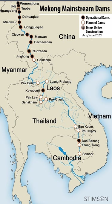

Fig. 7: Il corso del fiume Mekong con le principali strutture idrauliche
Quantitatively, the Mekong is certainly a river that can be defined as imposing. With a length of almost 5,000 km (4,880 km), the Mekong is the longest river in Indochina and the seventh in the world. Equipped with a drainage basin of absolute importance (a good 810,000 km²), it plays a leading role in the socio-economic well-being of millions of Asian citizens. After a long and tortuous pilgrimage that originates in the Tibetan mountains, the Mekong ends its "course" in Cambodia and flows into the South China Sea.
Until the early 2000s, this river boasted the largest inland fishery in the world, which represented about 25% of the global freshwater catch. This was due largely to the almost total absence of hydraulic infrastructure that could alter the flow of water and the volume of water directed towards "downstream". Until a few years ago, the presence of over 500 known species of fish was able to support a population of 60 million people along the river's shores belonging to various nations. In addition, farmers in the lands adjacent to the Mekong were able to produce enough rice to feed almost 300 million people each year, or about 95% of the inhabitants of Indochina.
However, today the situation is very different. As can be seen in Fig. 7, this impressive waterway has been massively exploited "upstream" by China. Since the 1990s, Beijing has built a series of dams that have significantly altered the flow of the river towards the South China Sea. The dams in question are eleven: Manwan (1993), Dachaoshan (2002), Jinghong (2008), Xiaowan (2009), Nuozhadu (2012), Gongguoqiao (2012), Miaowei (2017), Huangdeng (2017), Dahuaqiao (2018), Lidi (2018), Wunonglong (2018). In addition to these medium-large hydraulic infrastructures, we must add approximately 120 other small dams and hydroelectric plants that Beijing has built on its national territory along the course of the river. This situation has profoundly affected the water flow of the Mekong towards the other five countries located "downstream" [6]. As proof of this, it is worth referring to an interesting study carried out by Eyes on Earth in 2019. According to the American organization, the six dams built after the Nuozhadu (2012) have strongly contributed to altering the natural flow of the river; the research also states that: “one of the major consequences occurred in 2019, when the lower Mekong recorded one of its lowest river levels ever for much of the year”[7].
It is important to underline that the Eyes on Earth study, although interesting and reliable, is of American origin. Recently, the United States and China have often found themselves on opposing geopolitical fronts. In the last period, Beijing's impetuous growth in various aspects has raised no small amount of concern in Washington, where every Chinese move is meticulously monitored. Therefore, it is appropriate to evaluate the Eyes on Earth study in this context of mutual distrust that distinguishes the two main global powers. Nonetheless, it is evident that the construction of such a number of dams “upstream” has led to a concrete change in the flow of the Mekong River towards the south. As proof of this, it is useful to point out that in 2019 some satellites detected a higher-than-average natural flow in the Chinese portion of the river. Among the various causes, it is possible to take into consideration Beijing's activity aimed at retaining large quantities of water. This could have been the direct cause of the enormous drought problems, as well as of huge economic difficulties, which have occurred in the "downstream" states, where the river itself flows before flowing into the South China Sea[8].
Conclusion
In light of what has been discussed in this report, it is more than evident that the Tibetan Plateau currently plays a leading role in the so-called “hydro-strategy”. The latter is a subject that is increasingly emerging both at a geo-strategic level and with regard to international relations. For a series of reasons, mostly attributable to climate change, the growth of the global population and progressive mass urbanization, water resources will acquire more and more value in the years to come. Therefore, the control of sources, especially if pertaining to large trans-border rivers, will become increasingly important as time goes by.
Tibet is undoubtedly one of the most strategically important regions not only in the Asian continent but globally. This is due to several factors. First of all, because of its significant geographical position. In this regard, it should be considered that the Tibetan Plateau is located on the border between the two most populous nations in the world; therefore, everything that happens in Tibet does not have a simple regional relevance. The implications of a possible “Tibetan crisis” could involve billions of individuals and, consequently, have significant impacts on the entire International Community. Any tensions between the second world economic power (China) and the future most populous state in the world (India), inevitably also concern nations that geographically appear “far away”.
Secondly, Tibet is the water reservoir of South-East Asia. As analyzed in this report, hundreds of millions of people depend on the water that flows in the rivers whose source lies precisely on the Tibetan plateau. Any tension or threat to the status quo of this immense and impervious region can lead to very serious inconveniences for a considerable number of people. A number that is also destined to increase steadily over the next few years, given the high rate of population growth that already characterizes many Asian countries.
By virtue of its extremely favorable geographical position, being "upstream" of the vast majority of the great Asian trans-border rivers, China is the nation that benefits most from the Tibetan water resources. Without a doubt, Beijing plays a role of absolute importance in terms of hydro-strategy, so much so that it is not uncommon to identify China as a water super power. This situation has become even more evident over the last 10 years, after the Chinese began to exploit the water resources present in their national territory in a copious manner. The hydroelectric energy that China obtains from the exploitation of Tibetan waterways is extremely advantageous in various respects: it reduces the use of traditional (polluting) fossil fuels, offers low-cost energy solutions and allows for constant control over many "downstream" countries. The latter in fact find themselves having to passively manage the actions that the Chinese undertake from time to time on the trans-border rivers. From this perspective, the Mekong story is extremely exhaustive. The various dams built and managed by Beijing have significantly altered the flow of water southwards, resulting in changes to the socioeconomic structure of millions of Asian citizens living in five different countries.
It is not uncommon for measures adopted by Beijing on rivers that originate in the Tibetan plateau to cause tensions with neighbouring states. The most serious clashes have occurred with India, whose dependence on Chinese Tibet for water supplies is clear for all to see. In fact, it is enough to consult a geographical map to realise how much the entire territory of north-western India is in fact conditioned by the flow of water that comes from Tibetan rivers. As analysed above, other large and populous nations are very much conditioned by the water policies adopted by Beijing. Therefore, in light of what has been written, it is not an exaggeration to say that China, by virtue of its control over Tibet, is in fact the hegemonic nation in the fight for Asian water supplies.
_______________________________________________________________________________________________________________________________________________________________
[1] Con più di 166 milioni di persone, il Bangladesh è l’ottavo Paese popoloso del pianeta, dopo la Nigeria. Inoltre, con una superficie tutto sommato poco estesa rispetto al numero di abitanti (poco più di 147.000 km quadrati), il Bangladesh è uno degli Stati più densamente popolati al mondo.
[2]https://www.corriere.it/ambiente/speciali/2014/giornata-mondiale-acqua/notizie/arsenico-nell-acqua-piu-grande-caso-avvelenamento-collettivo-5e3796d2-adff-11e3-a415-108350ae7b5e.shtml.
[3] https://www.bbc.com/news/10358063.
[4] Yangon, grande città di 5.5 milioni di persone, è stata capitale del Paese fino a che nel marzo 2006 la giunta militare allora al potere non designò un’altra città, Naypyidaw, come capitale ufficiale del Myanmar. Per ulteriori dettagli sulla questione si rimanda a Filippo Verre, Chinese hydropower policy in Myanmar. The cases of Yadanabon Bridge and Myitsone Dam, in “Rivista di Studi Politici Internazionali”, Issue 2 Volume 88, pp. 225-244, 2021.
[5] Per ulteriori dettagli si rimanda a Filippo Verre, ivi.
[6] https://aspeniaonline.it/il-fiume-mekong-geopolitica-infrastrutturale-e-impatto-ambientale/.
[7] https://geopolitica.info/il-fiume-mekong-e-la-guerra-dellacqua/.
[8] https://geopolitica.info/il-fiume-mekong-e-la-guerra-dellacqua/.
Abaqua
Via Cassia, 615
00189 Roma (RM)
© 2024. All rights reserved.
Codice Fiscale: 96584590580


